


le locheur

louis4
User
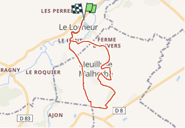

Length
7.5 km

Max alt
140 m

Uphill gradient
130 m
Km-Effort
9.2 km

Min alt
55 m

Downhill gradient
130 m
Boucle
Yes
Creation date :
2022-11-08 08:35:53.263
Updated on :
2022-11-08 11:00:43.234
2h24
Difficulty : Medium

FREE GPS app for hiking
 SityTrail
IGN / Geographical institutes
SityTrail Plus
The world is yours!
About
Trail Walking of 7.5 km to be discovered at Normandy, Calvados, Val d'Arry. This trail is proposed by louis4.
Positioning
Country:
France
Region :
Normandy
Department/Province :
Calvados
Municipality :
Val d'Arry
Location:
Le Locheur
Start:(Dec)
Start:(UTM)
678944 ; 5442103 (30U) N.
Comments